Effective immediately the trail to the summit of Owls Head in the town of Keene in the Adirondacks is closed to public access and use on weekends.
The trailhead and all but the last 0.1 mile of the trail are located on private lands. The large number of vehicles parked on the private road during the Memorial Day weekend blocked access for private landowners, and now the landowners are prohibiting the public to park on the private road between 4 p.m. Friday and 7 a.m. Monday and have posted signs along the road reflecting this decision.
The trail to the summit of Owls Head is not an official DEC trail nor does DEC have an easement for public use on the trail – the landowner has allowed the public to use the trail. However, the landowner has informed DEC the trail will be closed for public use at the end of this hiking season.
DEC is in the process of identifying an alternate trail route on Forest Preserve lands from the Molly Nye Road on the opposite side of the mountain, and will pursue an amendment to the High Peaks Wilderness Unit Management Plan which would be necessary to facilitate construction of a new trailhead and trail.
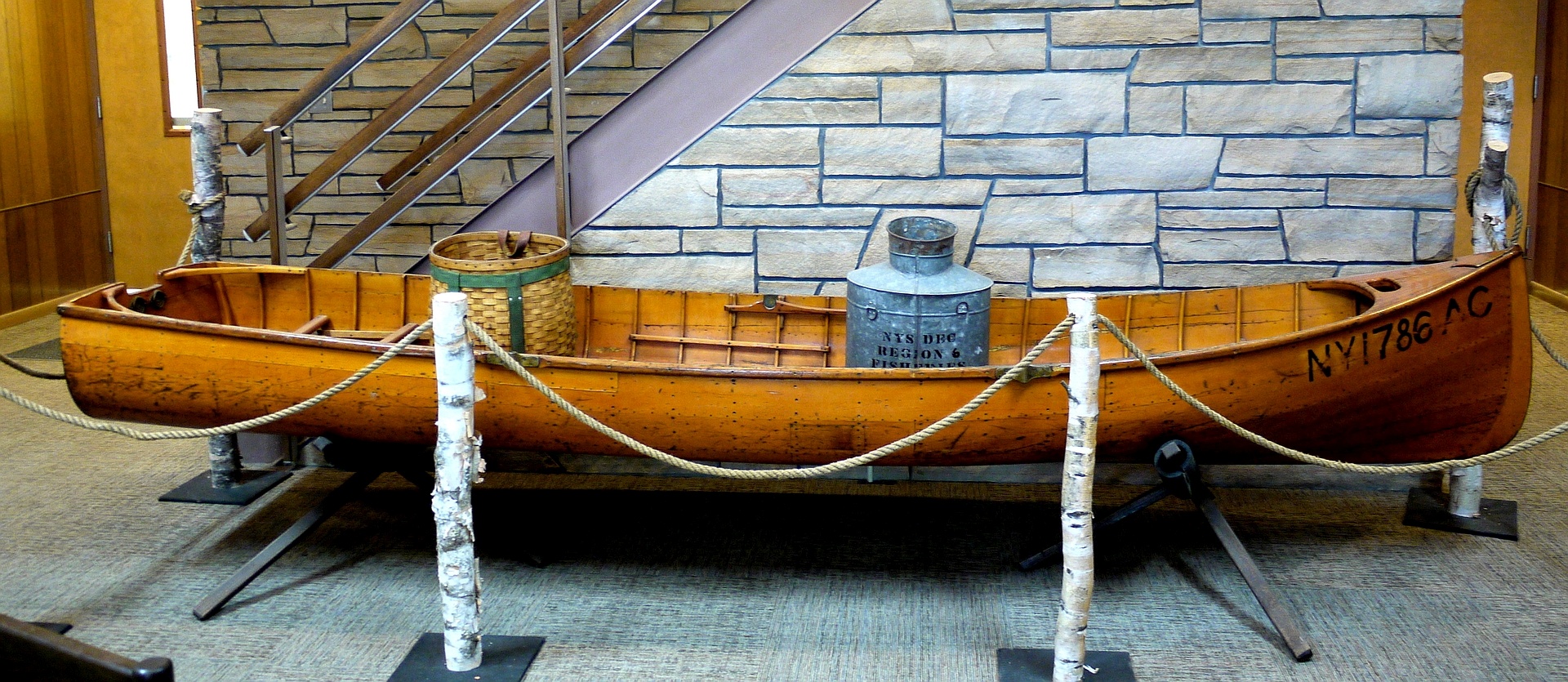
14 Ft Square Stern Ceder Guide Boat. Designed and built by Willard Hanmer of Saranac Lake in 1951. Purchased and used by NYSDEC Fisheries. 300+ miles estimated distance portaged during 15 years of service. 3 HP motor, 6 mph fully loaded (65 lbs). Currently displayed at Ray Brook HQ.
WEEKEND SNOW FORECAST: Weather forecasts vary but some weather services forecast accumulations of snow ranging from three inches to a foot this weekend throughout most of the Adirondacks.
The deepest snows are forecast for the Northwestern Adirondacks and the High Peaks region.
Moderate to deeper snow depths are forecast for the Western, Central (West & East), Northern and Northeastern Adirondacks.
Little to no snow is forecast for the Eastern and Southern Adirondacks.
Snow depths will be deeper in higher elevations.
Hikers should plan and prepare accordingly.
Rain, Snow, and Wind: Significant amounts of rain are forecast through the weekend with rain mixing with snow before changing to all snow as described above. Winds will get stronger through the weekend. Check the current National Weather Service Weather Forecast (leaves DEC website) and the National Weather Service NERFC Snow Page (leaves DEC website) for the latest snow information.
High Elevation Summits:Temperatures will be colder, winds will be stronger, and snow will be present and deeper than depths at trailheads on summits. Sight distance will be limited, sometimes significantly, when clouds cover the summits. Check the Mountain Point Forecasts (leaves DEC website) for selected summitsNational Weather Service Mountain Point Forecasts.
Trail Conditions: Trails will be wet and muddy through midday Saturday and then become a mix of water, mud, ice, and snow before becoming snow covered as described above.
Wet leaves, snow and ice will make for slippery trails – wear proper footwear and traction devices.
Snowshoes will be warranted late Saturday and on Sunday in the areas forecast to have moderate to deep snow cover, and in higher elevations.
Remain on trails. Walk through mud & water and on snow & ice to prevent further eroding trails and damaging trailside vegetation.
Avoid Hypothermia: The forecasted wet and cold weather provides ideal conditions for hypothermia.
Wear waterproof outer layers.
Wear layers of fleece, wool, and other non-cotton clothing.
Pack extra clothing including a fleece, wool or other non-cotton jacket or sweater.
Add or remove layers to maintain a comfortable body temperature.
Wear cold weather hat and gloves (or mittens).
Eat, drink and rest often.
Shorter Days: Autumn has arrived the sun sets earlier each day.
Sunset is around 6:00 pm, earlier in deep valleys and on northern and eastern facing slopes.
It will become darker sooner when skies are cloud covered.
Plan to return to the trailhead by sunset but
always carry a flashlight or headlamp just in case.
Blowdown: Blowdown (fallen or hanging trees, limbs, and branches) may be present on trails as winds strengthen, especially on trails in the higher elevations.

 The trailhead and all but the last 0.1 mile of the trail are located on private lands. The large number of vehicles parked on the private road during the Memorial Day weekend blocked access for private landowners, and now the landowners are prohibiting the public to park on the private road between 4 p.m. Friday and 7 a.m. Monday and have posted signs along the road reflecting this decision.