Adirondack Base Camp header image

Entries Tagged as 'fish'

DEC Proposal to Change Fishing Regulations – Adirondacks

February 16th, 2012 · 1 Comment · Adirondack News

The New York State Department of Environmental Conservation (DEC) announced today some proposed changes to the state’s freshwater fishing regulations.

“New York provides some of the best fishing in the nation and every two years DEC modifies existing freshwater sportfishing regulations and proposes new regulations to help ensure this remains the case,” said Assistant Commissioner for Natural Resources Kathleen Moser. “We encourage anglers to review these proposed changes and provide DEC with comments.”

The proposed regulation changes are the result of careful assessment of the status of existing fish populations and the desires of anglers for enhanced fishing opportunities. Several of the changes being considered are to remove special regulations that are no longer warranted.

These proposed changes are available on the DEC’s website, and feedback from all interested parties is welcomed.

Proposed changes which impact Adirondack region fisheries

Draft regulation changes that pertain to walleye:

  • Establish a special walleye regulation of 18-inch minimum size and three per day in Lake Pleasant and Sacandaga Lake (Hamilton County) to aid restoration of the walleye populations in these waters.
  • Prohibit fishing in the following stream sections from March 16 until the first Saturday in May (opening day for walleye) to protect spawning walleye: Lake Pleasant outlet to the mouth of the Kunjamuk River (Hamilton County)

Draft regulations that pertain to trout and salmon:

  • Open Lake Kushaqua and Rollins Pond (Franklin County) to ice fishing for lake trout as these populations are considered stable enough to support this activity.
  • Open Blue Mountain Lake, Eagle Lake, Forked Lake, Gilman Lake, South Pond and Utowana Lake (Hamilton County) to ice fishing for landlocked salmon and reduce the daily limit for lake trout in these waters from three per day to two per day. Combined with an existing regulation this change will create a suite of nine lakes in Hamilton County that will have the same ice fishing regulations for lake trout and landlocked salmon.
  • Delete the catch and release trout regulation for Jordan River from Carry Falls Reservoir upstream to Franklin County line (St. Lawrence County) because this regulation is considered inappropriate for this remote stream section.

Draft regulations that pertain to ice fishing and baitfish:

  • Delete special ice fishing regulation for Square Pond (Franklin County) because this water will no longer be managed for trout.
  • Open specific waters to ice fishing currently deemed as trout waters in the counties of Herkimer, Jefferson, Lewis, Oneida and St. Lawrence Counties as ice fishing can be allowed for at these locations.
  • Provide for ice fishing at a privately managed water in Hamilton County (Salmon Pond) that is stocked with trout by a private party, as requested.

Draft regulations that pertain to gear and angling methods:

  • More clearly specify that attempting to take fish by snagging is prohibited.

DEC is proposing additional regulation changes to remove special regulations that are no longer relevant, to provide more clarity in the current regulations and to make minor adjustments to current language. The full text of the draft regulation as well as instructions for submitting comments can be found on DEC’s website at: Proposed Regulations

Comments on the proposals can be sent via e-mail to fishregs@gw.dec.state.ny.us, or mailed to Shaun Keeler, New York State DEC, Bureau of Fisheries, 625 Broadway, Albany, NY 12233-4753. Hard copies of the full text can be requested from Shaun Keeler at the same addresses listed above. Final regulations, following full review of public comments, will take effect October 1, 2012.

Tags: ···

DEC Reminds Anglers of New Ice Fishing Regulations

January 5th, 2012 · No Comments · Adirondack News

NYSDEC LogoWith the onset of winter, the thoughts of many anglers often turn to ice fishing and the New York State Department of Environmental Conservation (DEC) today reminds ice anglers about a recent change to the Environmental Conservation Law.

In waters where ice fishing is permitted, anglers will be allowed to use up to three lines and five tip-ups except as noted in special regulations for specific waters. Previously, ice anglers could only use two lines with five tip-ups.

“Ice fishing provides a great opportunity for people to get outdoors during the long winter months,” said DEC Assistant Commissioner for Natural Resources Kathy Moser. “According to a recent DEC survey, ice fishing participation has doubled over the past 10 years.”

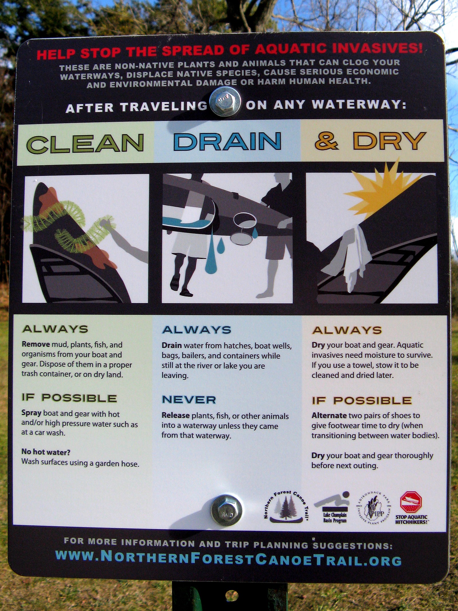
The use of fish for bait is very popular when ice fishing, and bait fish may be used in most but not all waters that are open to ice fishing. See DEC’s website for a list of special regulations by county to find out where bait fish can and cannot be used: www.dec.ny.gov/outdoor/71546.html.

Anglers are reminded to take these important steps when ice fishing:

  • Follow the bait fish regulations to prevent the spread of harmful fish diseases and invasive species.
  • Use only certified disease-free bait fish purchased at a local tackle store or use only personally collected bait fish for use in the same waterbody in which they were caught.
  • Check for sufficient ice thickness before venturing onto the ice.

A minimum of three to four inches of solid ice is usually safe for anglers on foot. However, ice thickness varies on every body of water and anglers should be particularly wary of areas of moving water and around boat docks/houses where “bubblers” may be installed to reduce ice buildup. DEC cautions that the presence of snowmobile tracks or footprints on the ice should not be taken as evidence of safe ice conditions. Individuals are strongly encouraged to check ice conditions for themselves and avoid situations that appear to present even a remote risk.

For more information on ice fishing, ice safety, and places to ice fish, please visit: http://www.dec.ny.gov/outdoor/7733.html. New York’s freshwater fishing regulations can be found at www.dec.ny.gov/outdoor/7917.html.

Tags: ···

Plattsburgh welcomes the FLW Tour to Lake Champlain this week

September 13th, 2011 · No Comments · Adirondack News

FREE Family Fun Zone and Outdoor Expo Saturday and Sunday

The Adirondack Coast Visitors Bureau and the City of Plattsburgh welcome the Walmart FLW Tour to Lake Champlain on Thursday, September 15th -Sunday, September 18th. Known as one of the most elite and competitive bass fishing tournaments hosted by FLW, there is sure to be a lot of excitement as more than 350 anglers battle for roughly $150,000 in cash and prizes.

Free Family Event
The Walmart FLW Tour’s very popular Family Fun Zone will be at Walmart in Consumer Square in Plattsburgh on Saturday, September 17th and Sunday September 18th from 12-4pm. The Family Fun Zone is free to the public and perfect for all ages featuring:

  • Interactive kids games
  • Meet and greet with the pros
  • Samples from sponsors
  • Ranger boat simulator rides
  • Casting and trout pond
  • Walmart Kid’s Zone
  • Chance to appear on national television
  • 300 rods and reels giveaway

Saturday and Sunday will conclude with the top anglers weighing in at 4pm.
Bass Pro Vic Vatalaro - FLW Lake Champlain
A Decade of Tournaments
This final tournament of the 2011 season also marks the end of Lake Champlain’s tenth year of welcoming pro anglers to the Adirondack Coast. “Lake Champlain is always a favorite stop among our anglers, and we couldn’t be more thrilled to be visiting with the Walmart FLW Tour stop in September,” said Kathy Fennel, FLW Outdoors president of operations. “The incredible hospitality extended to FLW Outdoors and our anglers is one of the reasons we continue to come back year after year.”

Tags: ····

Lake Champlain Fish and Wildlife Management Cooperative Will Treat Four Rivers and a Delta to Control Sea Lamprey Populations

September 2nd, 2011 · No Comments · Adirondack News

The Lake Champlain Fish and Wildlife Management Cooperative will be applying lampricide to portions of four tributaries to Lake Champlain and a delta complex during the months of September and October.

NYSDEC LogoThe U.S. Fish and Wildlife Service, Vermont Department of Fish and Wildlife, and New York State Department of Environmental Conservation will be treating the delta complex at the mouths of the Little Ausable and Ausable rivers, and the Boquet River, Mount Hope Brook, and Putnam Creek in New York. The Poultney River, which borders both states, including its Hubbardton River tributary in Vermont, will also be treated. Treatments are scheduled to begin with the delta complex in New York on September 7th. Lake level and weather conditions may affect scheduling and could result in the last treatment extending into October. These treatments are part of the Cooperative’s long-term sea lamprey control program for Lake Champlain. While trout and salmon populations of the lake are the primary beneficiaries of these efforts, lake sturgeon, walleye, and many other species also profit from sea lamprey control.

Larval sea lamprey live in rivers and on deltas for four years before transforming to their parasitic phase and emigrating to Lake Champlain where their effect on the fishery becomes apparent. One of the Cooperative’s Integrated Pest Management approaches is to apply selective pesticides (lampricides) to rivers and deltas in prescribed and precise concentrations. The concentrations used are carefully chosen and monitored to ensure effective elimination of sea lamprey larvae and protection of non-target species. TFM (3-trifluoromethyl-4-nitrophenol) will be applied in the rivers for 12-14 hours depending on conditions.

U.S. Fish and Wildlife ServiceThis year, for the first time in the Lake Champlain Basin, a second lampricide, Bayluscide 20% Emulsifiable Concentrate, is being included in the application on the Boquet River. The use of 1% Bayluscide with TFM reduces the amount of TFM needed by about 40%, resulting in a reduction of total lampricide applied and substantial cost savings. The delta area around the Little Ausable River and Ausable River mouths will be treated with Granular Bayluscide: lampricide-coated sand grains that dissolve after sinking to the bottom where they effectively kill sea lamprey larvae.

Our toll-free number (888-596-0611) provides information on the treatment schedule for each of the treatments, progress reports, updates on treatments, and water use advisories.

Temporary water use advisories will be in effect for each of the treatments to minimize human exposure to affected waters. Each state’s Department of Health recommends that the treated river and lake water not be used for drinking, swimming, fishing, irrigation, or livestock watering while the advisories are in effect.

Vermont Department of Fish and WildlifeThe treatments and water use advisories will have no effect on most residents in the Champlain Basin and no municipal water supply systems will be affected. Cooperative staff have identified all landowners with property in the affected areas. A letter was sent to residents informing them of the planned treatment and asking them if they or their livestock use water from a surface supply that will be affected by the treatment. Days before the treatments begin, another letter will be sent to inform residents of the impending treatment and to arrange any water usage accommodations.

Local television and radio stations will broadcast the dates when advisories begin and expire. The treatment schedule is subject to change as weather conditions, stream flows, or logistical issues may arise during the treatments. Residents will be kept apprised of any such changes through these media.

Annual assessments show sea lamprey wounding rates have been reduced from a high for landlocked Atlantic salmon of 79 wounds per 100 fish in 2003 to our management goal of 15 per 100 fish, reached for the first time in 2010. The lake trout wounding rate of 99 wounds per 100 fish seen in 2006 has been brought down to 40 per 100 fish in 2010. Several control initiatives are underway that will further reduce the sea lamprey population and reduce their impacts on Lake Champlain’s fish populations.

Sea lamprey control generates a favorable economic benefit/cost ratio by increasing angling opportunities and the time that boaters and anglers spend in the Lake Champlain area.

Communities and residents that utilize the following bodies of water should consult the advisory table below:

WATER USE ADVISORY AREAS
Stream Length of Advisory Area in Miles
Application Point to Stream Mouth Lake Area North of Stream Mouth Lake Area South of Stream Mouth
Ausable/Little Ausable Delta, NY NA 2.0 2.0
Boquet River, NY 2.6 2.0 2.0
Poultney (NY-VT) / Hubbardton River, VT 10.5/2.0 20.0* NA
Mount Hope Brook, NY 2.4 4.0** 2.0
Putnam Creek, NY 9.2 1.5 1.0

* includes the South lake from South Bay outlet to Larabees Point
** includes all of South Bay

Please contact Bradley Young, of the US Fish & Wildlife Service at (802) 872-0629 x19 if you have any questions.

Previously: Sea Lamprey Control Improves Lake Champlain Fisheries

Tags: ·····

Status of DEC Region 5 Boat Launches – June 16 2011

June 17th, 2011 · No Comments · Adirondack News

NYSDEC LogoLAKE CHAMPLAIN: Due to the high waters, floating docks have not been installed at DEC boat launches on Lake Champlain. While the boat launches are not closed to use the launching and retrieving boats will be difficult, especially for boaters not familiar with the location of ramps, walkways, docks, posts, etc. that are now underwater.

Clinton County

  • Peru Dock (Lake Champlain) – due to high waters the floating docks are not installed and the pump station is closed
  • Downtown Plattsburgh (Lake Champlain) – fully operational (new boat dock)
  • Chazy Lake – floating docks not installed
  • Taylor Pond – fully operational
  • Upper Chateaugay Lake – floating docks not installed

Essex County

  • Eagle Lake – fully operational
  • Crown Point (Lake Champlain) – due to high waters the floating dock is not installed
  • Port Douglas (Lake Champlain) – due to high waters the floating dock is not installed
  • Port Henry (Lake Champlain) – due to high waters the floating dock is not installed
  • Ticonderoga (Lake Champlain) – due to high waters the floating dock is not installed
  • Westport (Lake Champlain) – due to high waters the floating dock is not installed
  • Willsboro Bay (Lake Champlain) – due to high waters the floating dock is not installed
  • Mossy Point (Lake George) – fully operational
  • Lake Harris – fully operational
  • Lake Placid – fully operational
  • Lincoln Pond – fully operational
  • Paradox Lake – fully operational
  • Putnam Pond – fully operational

Franklin County

  • Buck Pond – fully operational
  • Fish Creek Pond – fully operational
  • Saranac Lake (Lake Flower) – fully operational
  • Meacham Lake – fully operational
  • Raquette River – fully operational
  • Rollins Pond – fully operational
  • Santa Clara – fully operational
  • Ampersand Bay (Lower Saranac Lake) – fully operational
  • Second Pond (Lower Saranac Lake) – fully operational, although end of walkways still underwater
  • South Creek (Middle Saranac Lake) – fully operational
  • Saranac Inn (Upper Saranac Lake) – fully operational
  • Tupper Lake – fully operational

Fulton County

  • Caroga Lake – fully operational
  • Broadalbin (Great Sacandaga Lake) – fully operational
  • Northampton (Great Sacandaga Lake) – fully operational
  • Northville (Great Sacandaga Lake) – fully operational
  • West Lake – fully operational

Hamilton County

  • Eighth Lake – fully operational
  • Forked Lake – fully operational
  • Inlet (Fourth Lake) – fully operational
  • Indian Lake – fully operational
  • Lake Durant – fully operational
  • Lake Eaton – fully operational
  • Lewey Lake – fully operational
  • Limekiln Lake – fully operational
  • Long Lake – fully operational
  • Little Sand Point Campground (Piseco Lake) – fully operational
  • Point Comfort Campground (Piseco Lake) – fully operational
  • Poplar Point Campground (Piseco Lake) – fully operational
  • Golden Beach (Raquette Lake) – fully operational
  • Moffit Beach (Sacandaga Lake) – fully operational
  • Seventh Lake – fully operational

Saratoga County

  • Edinburg (Great Sacandaga Lake) – fully operational
  • Rogers Island Pool (Hudson River) – floating dock is not installed

Warren County

  • Brant Lake – fully operational
  • Luzerne (Hudson River) – fully operation
  • Rogers Rock (Lake George) – fully operational

Washington County

  • Cossayuna Lake – fully operational
  • South Bay (Lake Champlain) – due to high waters the floating dock is not installed, also large mats of vegetative materials (floating bogs) are afloat in the general area around the boat launch site.

New York State Department of Environmental Conservation

Tags: ···

Status of DEC Recreational Facilities – June 16 2011

June 17th, 2011 · No Comments · Adirondack News

CLOSED FACILITIES

Clinton County

  • Ausable Point Campground and Day Use Area and access road

Essex County

  • None

Hamilton County

  • The eastern end of the Moose River Plains Road remains closed from the Cedar River gate.
  • Cedar River Road is also closed near its terminus, preventing motorized access to the campsites near Wakely Dam and the Cedar River Headquarters
  • Jessup River Road, preventing motor vehicle access to the Spruce Lake trailhead.

Warren County

  • Old Farm Road near Thirteenth Lake, preventing motor vehicle access to the trailhead – park at the snowplow turnaround
  • Lily Pond Road near Brant Lake
  • Gay Pond Road in the Hudson River Recreation Area.

Washington County

  • Dacy Clearing Road
  • Dacy Clearing Parking Lot

RECENTLY OPENED FACILITIES

All DEC Campgrounds and Day Use Areas except Ausable Point

Essex County

  • Moose Pond Road in Town of St. Armand
  • Elk Lake Road in the Town of North Hudson
  • Connery Pond Road between Lake Placid and Wilmington

Franklin County

  • Upper and Lower Locks on the Saranac Lakes Chain
  • Corey’s Road which accesses the western High Peaks from State Route 3
  • Madwaska Flow Road on the Santa Clara Tract Conservation Easement Lands
  • Pinnacle Road on the Santa Clara Tract Conservation Easement Lands

Hamilton County

  • The main Moose River Plains Road (Limekiln Lake-Cedar River Road) is open to motor vehicles from the Limekiln Lake gate at the western end near Inlet and to the Lost Ponds access road.
  • The Otter Brook Road is passable to motor vehicles to the Icehouse Pond trailhead.
  • Perkins Clearing Road north of Speculator
  • Old Military Road is open allowing motor vehicle access to the Pillsbury Mountain Trailhead.
  • Lake Lila Road in the William C. Whitney Wilderness, the road is still rough in some areas – use caution

Warren County

  • Jabe Pond Road near Hague
  • Lake George (Million Dollar) Beach (weekends only until June 24)
  • Prospect Mountain Veterans Memorial Toll Road in Lake George
  • River Road in the Hudson River Recreation Area, however it is muddy and rutted
  • Two designated campsites at Scofield Flats and two designated campsites at Pikes Beach in the Hudson River Recreation Area are currently restricted to day use only due to damage from flooding.

Washington County

  • Shelving Rock Road

New York State Department of Environmental Conservation

Tags: ····

Moose River Plains Road Partially Open for Memorial Day Weekend

May 27th, 2011 · No Comments · Adirondack News

NYSDEC LogoThe Moose River Plains road system in Hamilton County was partially opened today in time for the Memorial Day Weekend the New York State Department of Environmental Conservation (DEC) announced.

The Moose River Plains (Limekiln Lake-Cedar River Road) has been opened to motor vehicles from the Limekiln Lake gate at the western end near Inlet and to the Lost Ponds access road. Also the Otter Brook Road is passable to motor vehicles to the Icehouse Pond trailhead.

Moose River Plains

Rock Dam Road, the Cedar River Gate and the Wakely Dam camping area at the eastern end of the main road remain closed at this time.

The open section of the road provides access to 30 roadside campsites and numerous waters popular with anglers including Icehouse Pond, Helldiver Pond, Lost Ponds, Mitchell Ponds and Beaver Lake.

Other roads in the Adirondack Forest Preserve that have been reopened since yesterday include the Powley-Piseco Road in the Ferris Lake Wild Forest in Hamilton and Fulton Counties and the Jabe Pond Road in the Town of Hague, Warren County.

The opening of the Moose River Plains roads is due to the hard work of the local highway department staff and the successful partnership between DEC, the Towns of Inlet and Indian Lake and Hamilton County.

More details on road closures and openings, trail conditions and more can be found on the Adirondack Trail Information web pages, along with links to current weather forecasts, regulations, and safety tips.

Tags: ····