Adirondack Base Camp header image

Entries Tagged as 'conservation'

Cascade Mt Trailhead and Parking – Temporary Relocation and Reroute for Columbus Weekend / Canadian Thanksgiving

September 28th, 2017 · No Comments · Adirondack News

NOTICE TO HIKERS

Temporary Major Trailhead Relocations and Trail Reroutes
Effective Columbus Day and Canadian Thanksgiving Holiday Weekend (Fri, October 6 through Mon, October 9 2017)

DEC is taking the following actions to protect public safety at a very popular trailhead parking area in the Adirondacks during the busy holiday weekend.

Trailheads and trailhead parking for Cascade Mountain, Porter Mountain, and Pitchoff (West) Mountain will be relocated to the Mt. Van Hoevenberg Olympic Sports Complex at 220 Bobsled Lane, Lake Placid, NY.

Pull-offs along State Route 73 in the vicinity of the current trailhead will be blocked and roadside parking will be prohibited.

State Police and County Sheriff Deputies will enforce the parking prohibition. Drivers may be ticketed and vehicles towed.

Temporary Access to Cascade Mountain Map
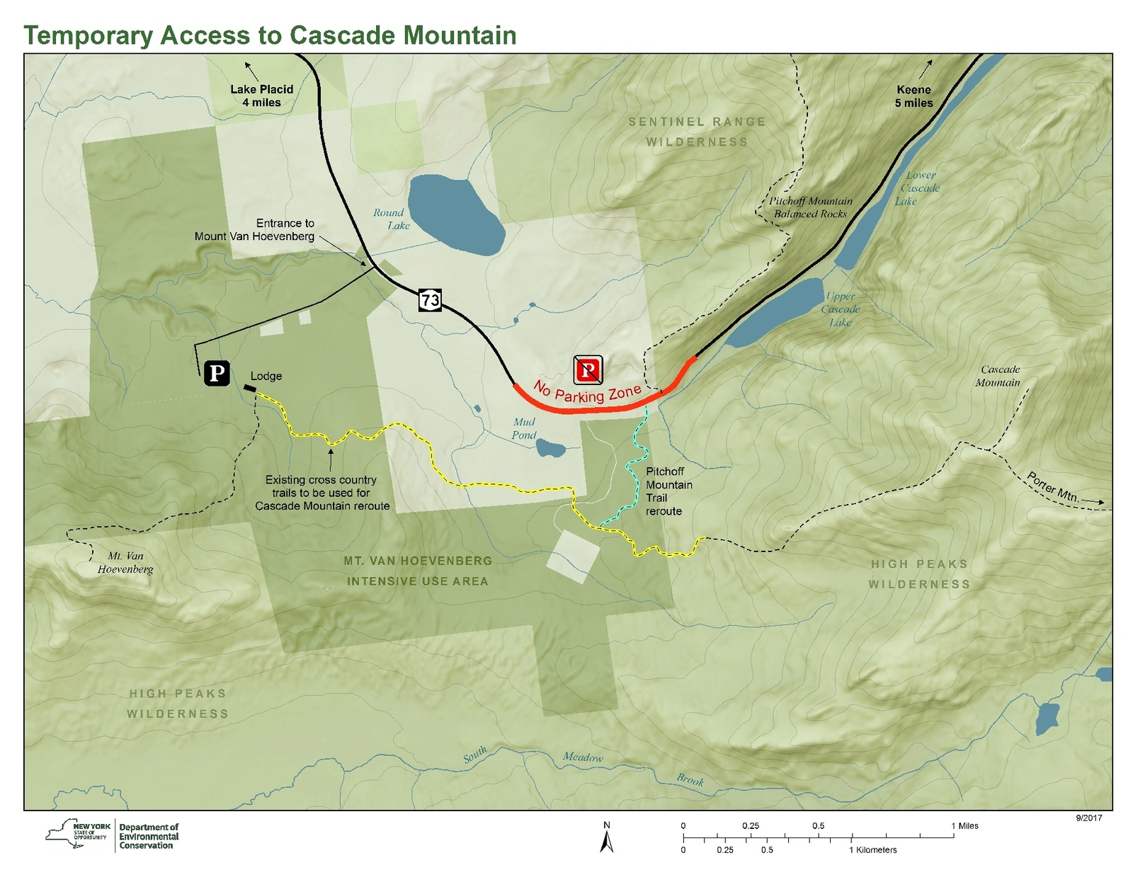
Temporary Access to Cascade Mountain Map – PDF

Hiking Trails

Cascade Mountain – A 2.0-mile marked route on the Olympic Sports Complex’s cross country ski trail system will connect hikers to the Cascade Mountain Trail via a newly constructed 0.6-mile connector trail. A round-trip hike using this route to the summit of Cascade Mountain is 8.6 miles long, a round-trip hike to the summit of Porter Mountain is 9.4 miles long.

Pitchoff Mountain – A 2.0 mile marked route across much of the same ski trail system will connect hikers to State Route 73. A 0.15-mile hike along the shoulder and across Route 73 will bring hikers to the access the current trailhead. A round-trip hike to the summit of Pitchoff Mountain using this route is 8.4 miles long.

Mt. Van Hoevenberg – The 1.6-mile trail (3.2 miles round trip) through the Olympic Sports Complex ascends 840 feet to 2,940-foot summit which provides amazing views of much of the High Peaks Wilderness and its many mountains.

Hikers seeking shorter hikes can check Hikes Outside the Adirondack High Peaks for hikes that will provide a similar experience and scenic views.

Mt. Van Hoevenberg Olympic Sports Complex
In addition to a safe place to park, hikers will be able to enjoy amenities such as bathrooms, food, and drink at the Cross Country Lodge is open 9:00 am to 4:30 pm daily. Also bobsled rides, mountain biking, and bus tours of the complex are available for a fee. (Olympic Sports Complex | Whiteface Mountain).

Tags: ····

Leave No Trace in the Adirondack Forest Preserve

May 23rd, 2017 · No Comments · Adirondack Life

Hiking

How to be a Low-impact Ninja in the Woods

Tags: ······

Status of Seasonal Access Roads in the Adirondacks

June 4th, 2015 · No Comments · Adirondack News

As of June 3, 2015:

See the Adirondack Trail Information web pages for more information.

Blue Mountain Lake Wild Forest/Township 19 Conservation Easement

  • O’Neill Flow Road is open to motor vehicles to the gate at Barker Pond Road.
  • Barker Pond Road is be open to motor vehicles to the Barker Pond parking lot.

Moose River Plains

  • Moose River Plains (Limekiln Lake-Cedar River) Road is open to motor vehicles its whole length from the Limekiln Lake gate near Inlet to the Cedar River Gate near Indian Lake.
  • Otter Brook Road is open to motor vehicles to the Squaw Lake barrier.
  • Rock Dam Road remains closed.

Perkins Clearing/Speculator Tree Farm

  • All roads designated for public motor vehicle traffic on the Perkins Clearing and Speculator Tree Farm Conservation Easements are open.
  • The section of Jessup River Road, in the Perkins Clearing Conservation Easement, leading to the Spruce Lake Trailhead is soft and should only be traveled by four-wheel drive trucks, SUVs and other high axle vehicles.

Essex Chain Lakes Complex

  • The Shadow Dam Gate and the Cornell/Deer Pond Road will be closed for 1-2 weeks beginning Monday, June 8 to allow for replacement of one of the bridges on the road which is in poor condition.
  • Chain Lakes Road South is open for motor vehicle access to the Old Gooley Club Parking Area.
  • Chain Lakes Road North and Drakes Mill Road are open to allow for public motor vehicle access to the Hudson River/Polaris Bridge Parking Area.

Lake George Wild Forest

  • Gay Pond Road in the Hudson River Recreation Area is open to motor vehicles but is rough.
  • Buttermilk Road Extension in the Hudson River Recreation Area is closed to all motor vehicles.
  • Lily Pond Road off State Route 8 south of Brant Lake is open to motor vehicles.
  • Jabe Pond Road off Split Rock Road and State Route 9N west of Lake George is open to motor vehicles.
  • Dacy Clearing Road is open to motor vehicles from the Hogtown Parking Lot to Dacy Clearing, it may be rough in spots.

Reminder: Seasonal access roads are rough, dirt or gravel roads. Four wheel drive trucks, SUVs and other high axle vehicles are recommended.

Tags: ····